Pioneering mission to map Titanic wreck begins with cutting-edge tech
On Friday, a mission aiming to examine the wreck of the Titanic thoroughly will commence. The latest equipment, capable of scanning every nook and cranny of the liner, will be used in the mission. "We want to see the wreck with a clarity and precision that's never before been achieved," says David Gallo in an interview with the BBC.

A team of imaging experts, scientists, and historians will set sail on Friday to the site of the Titanic's sinking. Their goal is to create the most detailed photographic record of the wreck. The team, departing from the American port in Providence, will be accompanied by BBC journalists.
Scientists will use state-of-the-art technology to scan every corner of the famous liner. This will allow them to obtain information about what is happening in different parts of the ship.
The expedition is organized by an American firm that has recovered so far about 5,500 objects from the wreck. Two robotic vehicles will be sent to the Titanic's wreck, diving deep into the ocean. During the mission, they are expected to take millions of high-resolution photographs and create a 3D model of all the elements.
We want to see the wreck with a clarity and precision that's never before been achieved, explained expedition leader David Gallo in an interview with the BBC.
They will spend 20 days above the wreck
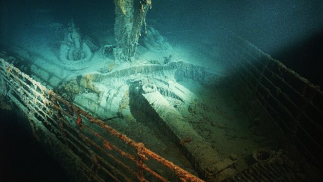
The logistics ship Dino Chouest will remain at sea for 20 days, weather permitting. The vessel will stay above the Titanic wreck, which rests at a depth of 12,500 feet. Although the wreck has been the subject of multiple studies since its discovery in 1985, a definitive map still does not exist.
While experts know the bow and stern of the broken ship, extensive areas of the surrounding debris field have only been superficially inspected. This is set to change with the latest mission. One remotely operated vehicle has several ultra-high-definition optical cameras and a special lighting system. The other has a suite of sensors and a laser scanner.
What happened to the Titanic's bow?
Participants in the expedition hope that the magnetometer mounted on one of the vehicles will detect all metals in the wreck site, even material buried in sediment out of sight. This could help uncover what happened to the liner's bow.
Hopefully, we'll be able to deduce whether or not the bow was crushed when it hit the seabed, or if it might actually extend down well into the sediment intact, said geophysics engineer Alison Proctor.
To remind everyone, the Titanic sank on the night of April 14-15, 1912. The liner collided with an iceberg and went to the bottom. Around 1,500 people lost their lives in the disaster, which constitutes over 80% of those on board.


